
|
The world is a book and those who do not travel read only one page.
My trip began in Yorktown, Virginia on June 9, 2002 and ended in Seattle, WA on August 22. My goal was to ride at least as far as Florence, Oregon (lower black dot on west coast) but planned to finish north of Florence. All in all, I rode the TransAm to Florence then up the Oregon Coast Route to the Pacific Coast route to Seattle, WA. I flew out of Seattle, WA on August 22. The route snakes through Virginia, Kentucky, Illinois, Missouri, Kansas, Colorado, Wyoming, Montana, Idaho, Oregon, and Washington states and will took 70 days. I had alloted 74 days to complete my trip and had originally intened to travel as far as Vancouver, British Columbia before flying home. I got ahead of my mileage "budget" early in the summer to allow for unforseen severe weather, mechanical failure, and illness that may have forced me to stop for a short time. By the time I reached northern Colorado my average mileage was above 70 miles per day even though I only needed to average around 62 miles per day. Luckily, I didn't have to take advantage of the built up mileage. I planned to end most days by making camp at a campground or a city park while staying at hotels, hostels, or bed-and-breakfasts more seldomly. It turned out that I didn't stay in my tent as much as I had intended since splitting hotel room costs with the people I rode with was economical and comfortable. Some choose to start in the west and others start in the east. Many people assume a prevailing westerly wind across the country will propel eastbound cyclists most of the way. In fact, the prevailing winds are variable and often have a southerly component. The Adventure Cycling Association reports that tours are more successful when they are westbound. Besides, it had that "go west, young man" appeal to it - just like the pioneers did. There are other routes that traverse the country. The Northern Tier route takes a northerly track but I had already visited many of those states, it is longer, it isn't necessarily any cooler, and there are probably more mosquitoes. The Southern Tier route looked too darned hot. There is also a Western Express route that shaves a few hundred miles off the trip but it goes right through the desert southwest. They would have found me burned to a crisp like a piece of bacon on the side of the road. The other option was to forge my own route but that requires a tremendous amount of research and scouting of the route. A book written in 1996 by Donna Lynn Ikenberry, Bicycling Coast to Coast, served as an indispensable planning aid. Many pieces of information from the book were be taken with me on the trip to guide me along the way. She broke the route into a 77 day trip but I worked a little faster than that so I could get back to my teaching duties in the fall. The Adventure Cycling Association provideed route maps and trip planning information. Just before I left I checked my maps against the addenda that ACA has online. |
|||||
| About the Ride Rider Bike Trailer Gear Route Technology Safety Miscellaneous My Writings Purposes Support the Ride Visitors since 1/1/2002 Updated 2.6.03 © 2001-2003 Lawrence J. Flint |
|||||
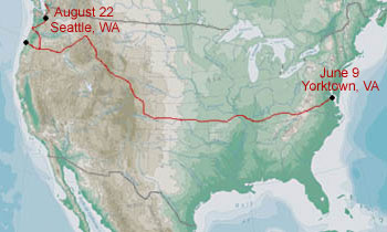 I followed the historic TransAmerica Trail. It was established in 1976 to commemorate the bicentennial of our country's birth and has been followed by many cyclists since.