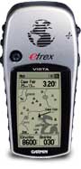
 A Garmin eTrex Vista global positioning satellite receiver was used to keep track of my position throughout the journey. It features an integrated altimeter, barometer, and compass as well as the typical GPS functions
Purposes
- It served as a navigation aid and replaced all the functions of a traditional cycle computer such as elapsed time, current speed, odometer, trip odometer, clock, maximum speed, and average speed. A traditional cycle computer was still be used as a backup and to authenticate the GPS data.
- Second, this model kept track of altitude trends. Each day the elevation profile for that segment was be downloaded into the computer along with other information such as elapsed distance and time. From this data I'll be able to chart an elevation profile for the entire Transamerica route. This will be accomplished in conjuction with Topo USA software that allows the route to be overlaid on 2-dimensional and 3-dimensional maps. Read more about mapping and elevation profiling.
- The data will also be analyzed to see the effect that hills have on the rider's performance. You can read about this in the Human Machine section.
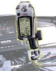 The GPS was attached to the bicycle handlebar with a RAM mounting system designed specifically for the eTrex GPS series. This is a very high quality mounting system that provides a very strong mounting point while allowing the GPS to be placed in many positions.
I came up with some custom power and computer connectivity solutions for the GPS. The power and serial cables that are commercially available are very expensive and did not meet my needs so I built a custom cable that interfaces with a USB-Serial converter.
Powering this unit from AA alkaline cells woud have been very tedious and expensive. There are two other 3 volt solutions that I have come up with:
- Primary source: Battery holder for C cells. Two C cells lasted much longer than the two AA batteries in the unit. This is for convenience sake and acts as a primary power source for the GPS.
- Secondary source: AA batteries were always installed in the GPS to act as a backup power source. The GPS automatically switches over to the AA batteries when external power drops below the required voltage and current.
Related links
