|
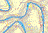
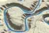
Elevation Profile and Mapping MacGPS Pro A piece of software called MacGPS Pro will be used to move the data from the GPS to the iBook computer. Since the GPS has a memory large enough to store an entire day worth of data it is not necessary to keep it plugged into a computer. Topo USA usually requires such a live connection but MacGPS Pro circumvents this. Physical connection between the GPS and computer is accomplished throug a USB port on the computer. I have devised an adaptor to connect the GPS to the USB port. Check back here for pictures soon. Topo USA Topo USA software from DeLorme will be used to build 2-dimensional and 3-dimensional maps for each daily segment of the route. The traditional 2-dimensional topographical maps are not as easy to read as 3-dimensional map images are. Below are examples of topographical map segments for a segment of the Bowknot quadrangle in Utah.
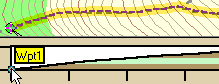
The GPS will be connected to the computer at the end of each day to download all waypoint data. Topo USA will then use this data to build a comprehensive 3-D map of the route with a route overlay. It is also capable of building an elevation profile for the route. Below is an animated elevation profile
Since Topo USA was designed to run on the Windows platform exclusively, Connectix VirtualPC will be employed to provide cross-platform capabilities. This software has many other cababilities that can be explored here.
|
|||||||
| About the Ride Rider Bike Trailer Gear Route Technology Safety Miscellaneous My Writings Purposes Support the Ride Visitors since 1/1/2002 © 2001-2003 Lawrence J. Flint |
|||||||