
Day 19 - Thursday, June 27, 2002
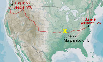 Golconda to Murphysboro, IL (Murphysboro State Park)
Ride length: 77.7 miles
Total to date: 1192.10 miles
Moving time: 6 hr 11 min.
Average Speed: 12.5 mph
Total ascent: 3619 ft.
Minimum elevation: 358 ft.
Maximum elevation: 870 ft.
Ending elevation: 376 ft.
Wind: 10-15 mph SSW wind during second half of the day (crosswind half the time; rear quarter wind the other half)
Weather: 72°F in the morning with a high dew point; got up to 85°F by noon; Mostly cloudy all day. Thunderstorms after 2:00 which cooled things down to 75°F. More pleasant riding than last week or so!
The Bike Surgeon does some surgery on the Rocket
Want to know what roads in Illinois look like?
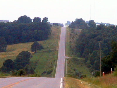
They really stink. Here's the deal with building roads: every state does it differently. In Virginia they draw a line from point A to point B and just go ahead and pave straight over any mountain, regardless of the grade. Virginia is really good about putting road signs on every road so you know exactly where you are. If a road has no outlet then they let you know with a sign at the beginning of the road. Wide, paved shoulders are the norm in Virginia. They also have very good bike route signs.
Kentucky is a little more thoughtful about their road design since they take topography into account. Kentucky is very good at using switchbacks and rock cuts in their mountain roads to minimize the grade and usually puts a shoulder on their roads. The only problem is that they put intermittent rumble strips across EVERY shoulder. There are absolutely no bike route signs in Kentucky. The only indication that I had of the TransAm route were two very, old signs I saw for "Bikecentennial" that were put up in 1976 out in the middle of nowhere.
Illinois is just terrible with roads. They utilize the "draw a straight line and pave it" approach like Virginia does. They do not shoulder anything except major highways which have a monstrously huge shoulder. It's all or nothing here! The condition of the road surface is usually very poor. I've never been on such rough, heaving pavement before in my life. The highways are a little better but they cut expansion joints in the road every 50 feet or so. Each one gives me a jolt in the butt when I hit one. I'm sure glad that I'll be out of this state tomorrow. If the entire TransAm route was along roads this bad then I'd probably go through lots and lots of tires and spokes.
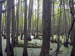
Anyway... I rode through the Shawnee National Forest for a while. Here are some pictures. The first one is of me and my bike at the entrance (duh). The second is of a swampy forest (that's probably not the right term) with green slime covering the water for thousands of acres.

They have a lot of prisons here. I went past two prisons, a prison work camp, and a youth "boot camp" today alone. It seems that the prison in Vienna may be closing because the AFSCME local union has placards along the road protesting the closing.
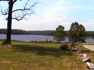 Just before Carbondale I rode through the Crab Orchard National Wildlife Refuge. It's a very natural place with lots of wetland and protected habitat for many animal and plant species. The Greater St. Louis Council of the Boy Scouts of America has a camp here on Little Grassy Lake. It reminded me of my 10 summers working at Heritage Reservation, Greater Pittsburgh Councils camp.
I went to the famous "Bike Surgeon" in Carbondale today to see about some repairs. Bill Watts owns the place and was a very good guy. I had the headset tightened, the brakes looked at and got a new cassette for the bike. The whole way from the coast I wished I had at least one lower gear than my bike came with. The largest cog in the rear was a 28 tooth gear and I know they make cassettes with more teeth than that. The owner had a new Shimano cassette that had a 30 tooth sprocket. Just what I needed! Twenty five dollars was the right price too. Two more teeth makes going up hills just that much easier. I gave it a try and it works well - no compatibility problems at all. I shouldn't have to dismount and walk my bike up the steepest hills any more and the more gradual hills won't be such a pain. This should also help my Achilles tendonitis (which didn't flare up today by the way) since I can spin faster with lower force. I should be set to make it the rest of the way now.
Before leaving Carbondale I stopped at a Chinese buffet restaurant to pig out. Lunch was $4.90 and I ate like a hog and drank lots of water. It was great deal! My fortune in the fortune cookie was "You are a person of culture." I then headed to Murphysboro to a supermarket. Just as I checked out it started to rain pretty good. I was going to try to make it to Chester today (for a total of 110 miles or so) but sat in the supermarket vestibule with my bike for an hour while the rain passed. A quick half hour ride led me to Murphysboro State Park where I got a shower and had dinner before it started to rain again. The clouds are really rumbling and it's raining pretty steadily now at 7:00pm. The rain has really cooled things off and this should relieve the dry spell they have had for the past two weeks around here - the farmers will be happy.
On to Missouri tomorrow - my fourth state. Illinois went by very quickly!
I'm getting a little ahead in my mileage. I've done an average of 62.7 miles per day so far including three short days. The first day was short because of time then I had two other short days due to my Achilles tendon problem in Virginia.
Food: McDonalds Deluxe Big Breakfast (1200 Cal.), large orange juice (300 Cal.), very large chef salad, french dressing (250 Cal.), 1 L gatorade (Starfruit - my favorite flavor!) (250 Cal.), Quaker Fruit & Oatmeal bar (130 Cal.), 2 egg rolls, 3 fried dumplings, serving of lo mein, serving of beef & broccoli over rice serving of sesame chicken over rice, 3 wontons in wonton soup, 2 sugar cookies, 1 fortune cookie, 1 peach, 7 L water, 1 box macaroni & cheese, 2 slices apple pie. Yum, yum!
Camping fee: $11.00